


Hydrologic Prediction
Surface Hydrology Forecasting and Prediction System
Of the many available hydrologic modeling systems, CHRS team considers the National Weather Service River Forecasting System (NWSRFS) as the focal point of our surface hydrology investigations. Our research attempts to contribute to the national weather services's efforts to develop and implement a moderized hydrologic forecasting system known as the Advanced Hydrologic Prediction Service (AHPS). AHPS is intended to be implemented by all of the 13 river forecast centers (RFCs) in the United States (shown below).
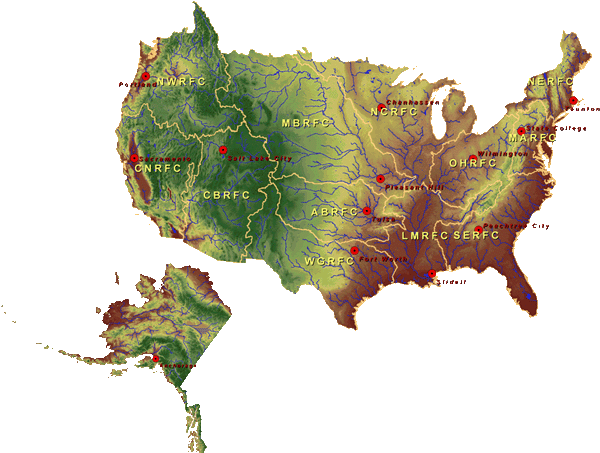
National Weather Service River Forecast Centers (RFC)
Currently, the National Weather Service River Forecast system is the core surface water hydrologic modeling system is an integrated modular modeling system, which enables watershed-based streamflow prediction systems to be constructed with characteristics specific to the forecast point. The system consists of three main components (1) Calibration system, (2) Operational forecast system, and (3) Extended streamflow prediction system (Figure Below)
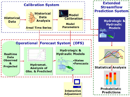
Key components of the NWSRFS
Our selection of the NWSRFS is based on the fact that it is the primary national system for flood warning. In fact, both our mesoscale modeling and precipitation estimation efforts focus on improving the predictions of the key meteorological input to the surface hydrologic model of the NWSRFS.
The hydrologic core of this system consists of the Sacramento Soil Moisture Accounting model (SAC-SMA; Burnash, 1995), the SNOW-17 snow model, and a suite of routing schemes. The SAC-SMA model is a complex conceptual hydrologic model. It is based on conceptualizing the soil profile as a series of reservoirs with capacities and release coefficients. The SAC-SMA is also one of the available hydrologic (Infiltration) models within the popular (HEC-HMS).
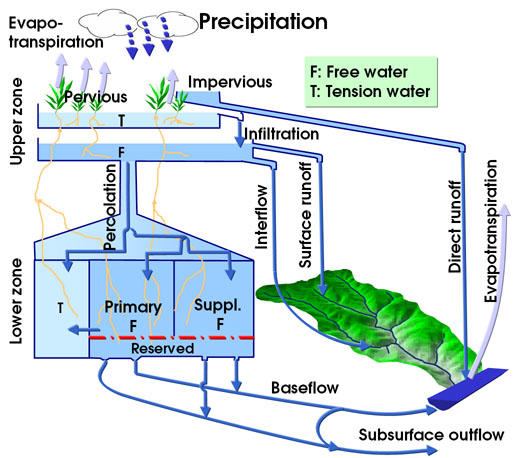
Schematic representation of the SAC-SMA.
In the next few years, CHRS researchers and graduate students will focus on:
- Improving the representation of hydrologic processes in the operational model with emphasis on adapting its major components to better represent the semi-arid hydrology, including the effects of topography and spatial variability,
- Implementing components and procedures to exploit the availability of satellite-based remotely sensed data,
- Investigating procedures for model initialization and parameterization, including techniques for regionalization, and
- Developing and implementing stochastic procedures for providing probabilistic forecasts that account for data and model uncertainty.
With respect to process improvement, the following aspects are being considered:
- Evapotranspiration (ET) is currently computed within the SAC-SMA model from monthly average potential evaporation estimates derived from national pan evaporation data. We intend to implement an ET module based on simple energy-balance formulations currently used within Land Surface Models (LSMs) coupled to global and regional atmospheric models. Remotely sensed vegetation products (Section V.2) and mesoscale model state variables (Section V.1) will be used to develop hourly and spatially varying evapotranspiration estimates.
- Runoff generation: Runoff generation within the SAC-SMA model is conceptualized from saturation excess physics that is most appropriate for humid environments. Hernandez et al. (2000) showed that representation of the infiltration excess runoff generation process characteristic of semi-arid environments requires consideration of the interaction between spatio-temporal variability in precipitation intensities and soil properties. We intend to investigate two infiltration excess modules based on the KINEROS model and the VIC-4L infiltration excess formulation.
- Snowmelt: Given that rapid snowmelt runoff is the major factor determining river flow in the spring (crucial to water supply and reservoir operational decision-making), accurate representation of the snowpack processes in the mountains of the Southwest is critical. The SNOW-17 model uses an air temperature index method (daily minimum-maximum temperature) to estimate the energy exchange across the snow-air interface for computing the accumulation and ablation of watershed snow pack. We intend to implement an improved snow component, running at a 1-hour time step, based on the 1-D snow water and energy balance model developed by Jin, et al. (1999).
- Routing: Rivers and stream channels in semi-arid regions vary between gaining and loosing systems depending on the interaction of the river channel with the groundwater table and the influence of riparian vegetation. We intend to implement a routing module that incorporates these effects, based on the work of Smith and Goodrich (1999) and current research on river systems being conducted by the USGS and SAHRA.
- Improve Mesoscale Modeling
- Improve time-varying boundary conditions using EOS SST data
- Improving the simulated triggering of convective events in urban areas
- Ensemble Weather Forecasting
- Improving snow modeling component in Land Surface Models
- Assimilation of Satellite Snow Data
- Usage of Remote-Sensing data
- Surface Hydrology Forecasting and Prediction System
Sponsors


UC Irvine | Engineering | Civil & Environmental Engineering | Physical Sciences | Earth System Sciences | OIT
© 2017 Center for Hydrometeorology and Remote Sensing
UCI Engineering Hall Suite 5300 (Building #308) Irvine, CA 92617
Back to Top