


Hydrologic Prediction
Improve Mesoscale Modeling
The coupled mesoscale model of the hydrometeorology of the SWUS is the integrating framework for the development of improved understanding of semi-arid hydrology. The model is essential for making short-term predictions of weather phenomena.
The model (MM5) has been implemented to take advantage of the continental-scale simulations and predictions generated by the national NCEP modeling system, which uses various operational mesoscale models to produce so-called “weather analyses” (fusions of model results and observations) and deterministic and ensemble model forecasts.
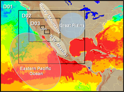
CHRS-mesoscale modeling domain, move mouse over image for key information
Figure (4) illustrates the mesoscale model configuration adopted by CHRS researchers in our efforts to improve hydrologic predictions over the southwestern U.S. The configuration consists of domain (D01, Fig. 3) encompassing at least 2-nested sub-domains (i.e., D02 and D03) with grid resolution varying from 108 km at D01, 36 km at D02, down to 12 km at D03. In addition, smaller areas (D04) within D03 will be modeled using 4-km grids located at areas of special research significance.
NCEP global model simulations (analyses or forecasts) at six-hourly temporal and 2.5 ° ´ 2.5 ° spatial resolutions are used to specify the time-varying boundary conditions at the edges of domain D01 (the NCEP/Eta model only covers the region north of 17 °N and is therefore not useful for the study region). Area D02 is centered over the primary study area to include several important regions: (a) eastern Pacific Ocean and Gulf of Mexico, (b) southwestern United States, (c) Rocky Mountains, (d) Great Plains, and (e) Mexico. Area D03 will cover an extended portion of the SWUS. This configuration is designed to allow us to focus on regional short-term forecasting and prediction.
- Improve Mesoscale Modeling
- Improve time-varying boundary conditions using EOS SST data
- Improving the simulated triggering of convective events in urban areas
- Ensemble Weather Forecasting
- Improving snow modeling component in Land Surface Models
- Assimilation of Satellite Snow Data
- Usage of Remote-Sensing data
- Surface Hydrology Forecasting and Prediction System
MM5 Model
NCEP-Reanalysis Atlas at the Climate Diagnostic Center (CDC) (Create your own plots and visualizations)
NCEP Eta Model Forecasts
Sponsors


UC Irvine | Engineering | Civil & Environmental Engineering | Physical Sciences | Earth System Sciences | OIT
© 2017 Center for Hydrometeorology and Remote Sensing
UCI Engineering Hall Suite 5300 (Building #308) Irvine, CA 92617
Back to Top