


Hydrologic Prediction
Improve time-varying boundary conditions using EOS SST data
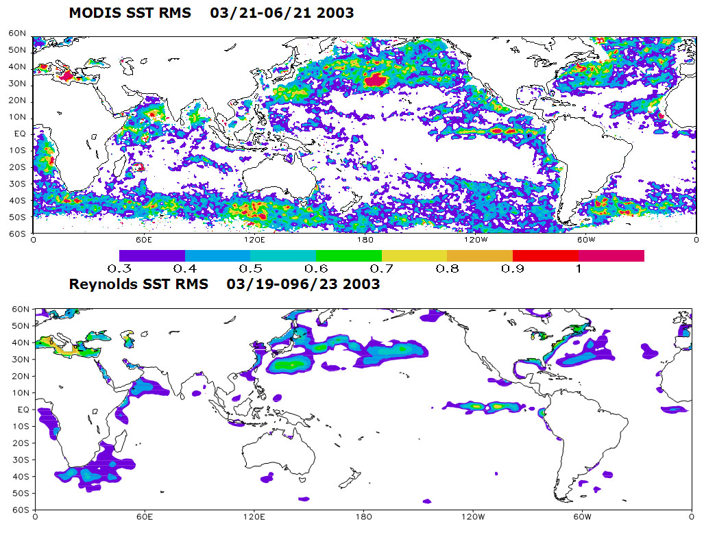
Recently released EOS SST products have greatly improved sensor quality and spatial and temporal resolutions (twice daily (day-night) and 4.63 km in MODIS SST) compared to the widely used Reynolds SST data (weekly and 1° ´ 1° ). The latter do not capture a number of interesting SST variation patterns (such as oceanic currents) and features (such as the diurnal variability) that are now visible using the MODIS data. In some regions, MODIS SST is about 2-3° C colder than the Reynolds SST. A wavelet analysis of the MODIS SST in the eastern Pacific Ocean (110° -150° W, 10° -24° N) shows strong 2- and 3-week wave components that have not been detected before. It is quite possible that these differences in SST can have significant impacts on weather/climate predictions.
Example of the Intraseasonal patterns of SST as observed by TERRA-MODIS (4.6 km) and Reynolds SST (1°). Notice the coherent structures in various areas of the globe. Also notice the higher level of details, particularly in the mid and Eastern Pacific ocean.
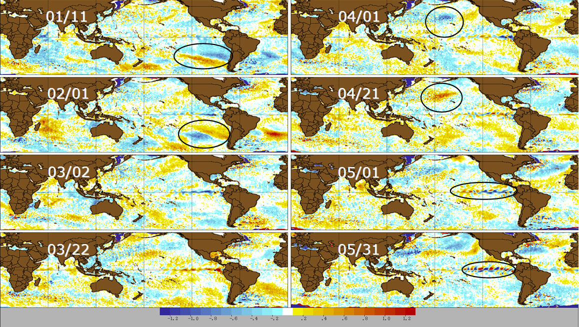
Intraseasonal patterns of SST as observed by TERRA-MODIS (4.6 km) for the Fall/Spring seasons. The data represents filtered SST.
Motivated by these initial results, CHRS researchers are now preparing the required data sets and configuring the mesoscale model to conduct a long-term experiment aiming to answer the following key questions.
- Do the apparent small scale, 20-60 day perturbations of SST shown in higher resolution satellite data represent actual observations of coherently structured intraseasonal variability of SST, and if so, how accurately can they be characterized
- Can the coherent, well structured intraseasonal variability of SST be reconciled with/and or confirmed by observations of other elements of the water and energy cycle at similar spatial and temporal scales
- What are the physical mechanisms through which small scale, yet well structured perturbations in SST propagate through the ocean-atmosphere/atmosphere-land system of NA and its surrounding atmospheric region, and what are the pathways " -> " that describe the potential propagation of SST -> (local sensible heat /latent heat fluxes) -> moisture transport -> downstream latent heat release as precipitation occurs -> Precipitation over the United States?
- How well can these mechanisms and pathways be captured by RCM simulations, and what key model deficiencies must be addressed to improve the model's ability to capture the effects of intraseasonal variability of SST on the water and energy exchange at the air-sea and air-land interfaces over the United States and its surrounding oceanic regions?
- Will such improvements enhance the predictability, even in a probabilistic sense of the variability of hydrometerologic conditions in the United States, and at what spatial and temporal scales would such predictability be most relevant to supporting decision-makers in their preparation for increased probability of drought onsets or wet seasons?
- Improve Mesoscale Modeling
- Improve time-varying boundary conditions using EOS SST data
- Improving the simulated triggering of convective events in urban areas
- Ensemble Weather Forecasting
- Improving snow modeling component in Land Surface Models
- Assimilation of Satellite Snow Data
- Usage of Remote-Sensing data
- Surface Hydrology Forecasting and Prediction System
Sponsors


UC Irvine | Engineering | Civil & Environmental Engineering | Physical Sciences | Earth System Sciences | OIT
© 2017 Center for Hydrometeorology and Remote Sensing
UCI Engineering Hall Suite 5300 (Building #308) Irvine, CA 92617
Back to Top