


Satellite Precipitation
Data Merging from Multiple Sensors
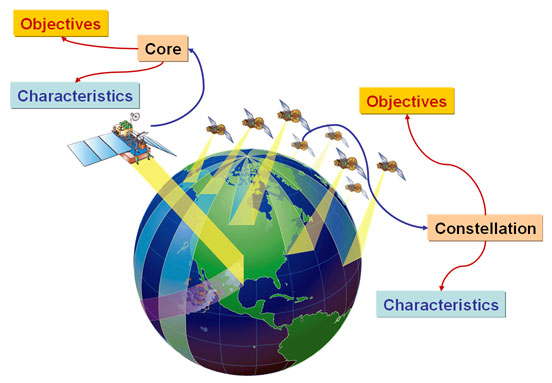
In 2013, NASA will launch the first satellite of the Global Precipitation Masurement (GPM) mission. The mission, which is a joint efforts between the US's National Aeronautics and Space Administration (NASA) and Japan's National Space Development Agency (NASDA), aims at providing high resolution, frequent, and accurate, observation of precipitation and of atmospheric variables related to precipitation at global scale. GPM consists of TRMM-like core satellite, and a constellation of pre-existing, experiemental, and planned satellites with microwave instruments on board (See image below).
In anticipation of the amount of data, and the challenges associated with development of systematic measurements of global precipitation using multiple satellite data, CHRS researchers are conducting research on merging precipitation observations from various sources.
In addition to satellites, precipitation observations are available from many sources, such as satellites, radar, and gauges. However, these sources differ significantly in the scale, resolution and information content. Geostationary infrared and visible sensors sample cloud top temperature and albedo every 30-minutes, providing rapid global observations, but are indirectly related to surface rainfall rates. Microwave sensors carried by low earth orbital satellites detect the water content of rain clouds more directly, but provide limited samples in one day. Rain gauges and radar provide relatively continuous and direct measurement of surface rainfall; however, gauge locations are sparsely distributed and only provide point-scale measurements, while radar coverage is limited by topography. Because each measurement technology has its own strengths and weaknesses, suitable combination of sensor technology may provide better measurement than one sensor alone.
CHRS team is currently developing high-quality precipitation estimates using data fusion methodology to combine several different precipitation estimates and data sources. This system merges multi-channel imagery from GOES-8 and GOES-10 with precipitation estimates generated by multi-channel microwave sensors carried by TRMM, NOAA-15, -16, and -17, DMSP F-13, F-14, and F-15 satellites, and ground-based radar rainfall estimates.
Satellite Precipitation Activities:
Other Links:
Satellite Data
NASA Global Precipitation Measurement (GPM)
Global Precipitation Climatology Project (GPCP)
Global Precipitatoin Climatology Centre (GPCC)
International Precipitation Working Group (IPWG)
NOAA NexRAD Radar Data
NOAA's Comprehensive Large Array Stewardship System (CLASS)
SAA Products Description
National Center for Environmental Prediction (NCEP) (temporary page)
NCEP-NOAA Global IR Data
NOAA Office of Satellite Operations
Geostationary Satellites
Polar Orbiting Satellites
Goddard Space Flight Center DAAC
TRMM Homepage
HyDIS-Hydis PERISANN Map Server