


Satellite Precipitation
The PERSIANN System
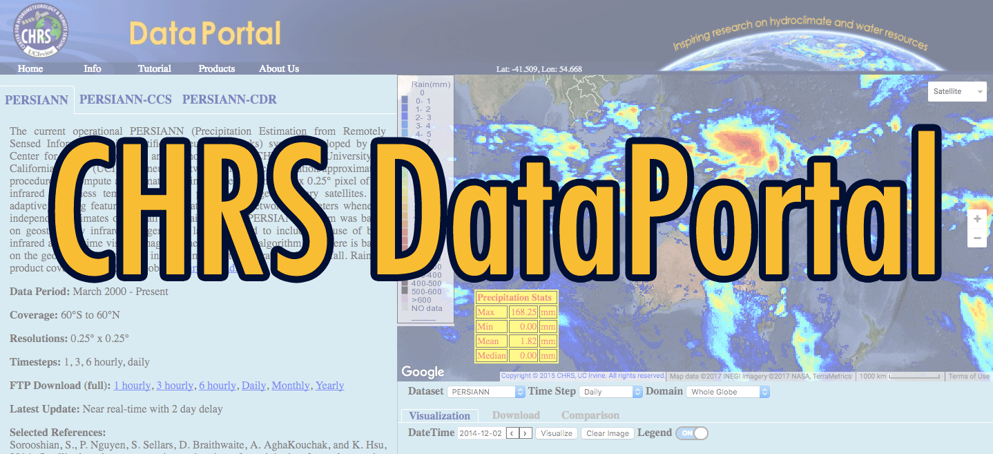
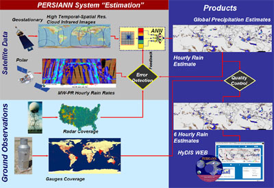
The Current operational PERSIANN (Precipitation Estimation from Remotely Sensed Information using Artificial Neural Networks) system uses neural network function classification/approximation procedures to compute an estimate of rainfall rate at each 0.25° x 0.25° pixel of the infrared brightness temperature image provided by geostationary satellites. An adaptive training feature facilitates updating of the network parameters whenever independent estimates of rainfall are available. The PERSIANN system was based on geostationary infrared imagery and later extended to include the use of both infrared and daytime visible imagery. The PERSIANN algorithm used here is based on the geostationary longwave infrared imagery to generate global rainfall. Rainfall product covers 50°S to 50°N globally.
Flowchart of the operational PERSIANN system.
The system uses grid infrared images of global geosynchronous satellites (GOES-8, GOES-10, GMS-5, Metsat-6, and Metsat-7) provided by CPC, NOAA to generate 30-minute rain rates are aggregated to 6-hour accumulated rainfall. Model parameters are regularly updated using rainfall estimates from low-orbital satellites, including TRMM, NOAA-15, -16, -17, DMSP F13, F14, F15.
Spectral Intervals and Applicable Satellites
- Long wave infrared channel (10.2-11.2 um) from GOES-8, GOES-10, GMS-5, Meteosat-6, and Meteosat-7.
- Instantaneous rainfall estimates from TRMM, NOAA, and DMSP satellites.
Spatial Scale: 0.25° x 0.25° latitude/longitude scale
Temporal Scale: 30 minutes accumulated to 6-hour accumulated rainfall
Operational procedure
Since its early inception in 1997, PERSIANN has been a continuously evolving system. The current operational version of PERSIANN (link to appropriate decision support page) generates the above-described global precipitation maps product with two days delay time. The delay is due to international data access agreements, which allows us to access global IR composites two days after acquisition.
The processing steps are as follows:
- Global full resolution IR composites are downloaded from the NCEP Server on daily basis, these are 15 minute
- TRMM level 2A (TRMM-2A25) microwave imager data are downloaded twice a day also with two days delay.
- The NOAA Satellite Active Archive system is polled every 30 minutes to acquire the most recent microwave-based precipitation estimate from 6 additional microwave instruments on board NOAA K,L, and M (15,16 and 17, respectively) and DMSP 7,8 and 9. Because these data are available in real-near time, they are archived for use whenever the corresponding global IR composites become available.
- Each day, CHRS’s the Global IR data is used to produce the intermediate 30 minutes 4 km precipitation product with the neural network model is trained using all microwave-based precipitation estimates available for the given day.
- The intermediate product is then aggregated to 0.25° six hourly precipitation maps 3. And the product is released as provisional PERSIANN precipitation estimates. At the same time, 24 hr, 3, 5, 7, 10, 15, and 30 days total precipitation products are also created for distribution over the HyDIS-GWADI (Link) Server.
Satellite Precipitation Activities:
Other Links:
PERSIANN Validation Links
US (hosted by NOAA-CPC/NCEP)
Australia: Hosted by the Bureau of Meteorology, Australia
Satellite Data
NASA Global Precipitation Measurement (GPM)
Global Precipitation Climatology Project (GPCP)
Global Precipitation Climatology Centre (GPCC)
International Precipitation Working Group (IPWG)
NOAA NexRAD Radar Data
NOAA's Comprehensive Large Array Stewardship System (CLASS)
SAA Products Description
National Center for Environmental Prediction (NCEP) (temporary page)
NCEP-NOAA Global IR Data
NOAA Office of Satellite Operations
Geostationary Satellites
Polar Orbiting Satellites
Goddard Space Flight Center DAAC
TRMM Homepage
HyDIS-Hydis PERISANN Map Server